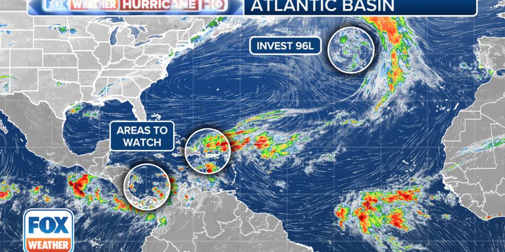
Another named storm – or perhaps two named storms! – is not out of the question as the final month of the 2024 Atlantic hurricane season counts down.Nov. 30 marks the end of the Atlantic hurricane season, and that can’t come soon enough. In the meantime, there are three areas worth watching, according to the National Hurricane Center.The area with the most chance of development over the next week is in the southwestern Caribbean Sea. The NHC said some gradual development is possible over the next two days, and a tropical depression could form over the weekend or early next week as the area of low pressure moves in a northern-northwestern direction. As of the latest advisory, the NHC is giving this area a high chance of development within the next week.”The computer forecast models all point to a broad area of low pressure developing around Sunday, which spawns a tropical depression or tropical storm next week,” says FOX Weather Hurricane Specialist Bryan Norcross. “The system will draw rich tropical moisture from the south, which could cause flooding problems for the northern Caribbean islands, including the Dominican Republic, Haiti, Jamaica, Cuba, and the Cayman Islands.Norcross says the consensus of the computer forecasts is that a depression or possibly a tropical storm will move into the Gulf of Mexico around Thursday. “There is no consensus, however, on how strong the system will be at that point,” he said. “We are talking a week from now, so the forecasts are fuzzy, but a combination of cooler Gulf waters, dry air, and hostile upper winds should keep a strong storm from affecting the U.S. Gulf Coast. That’s based on what we know now, of course.”BRYAN NORCROSS: FORECAST CONSENSUS SHOWS A TROPICAL SYSTEM TRACKING TOWARD THE GULF NEXT WEEKThe next name on the 2024 Atlantic list is Patty, though another storm brewing in the North Atlantic may take that name first, leaving this disturbance with the name Rafael.The NHC is also monitoring an area of low pressure in the northeastern Caribbean Sea, but this system has a low chance of developing over the next week. It’s likely to become absorbed in the first area to watch in the southwest Caribbean Sea.HOW TO WATCH FOX WEATHERIn the North Atlantic, the NHC is watching an area of showers and thunderstorms near the center of a low-pressure area a few hundred miles west of the Azores and has now designated the disturbance as Invest 96L. The system showed increased signs of intensity on Friday afternoon and the NHC has now increased the odds of development into the medium category. The system already meets the wind criteria to be named with maximum speeds at 50 mph, but just needs to develop a tropical or subtropical core. “If (the NHC) has confidence that this has a unified core in and of itself, and it’s over warm enough water for tropical characteristics, then it will get the name – probably Subtropical Storm Patty – maybe Tropical Storm Patty,” Norcross said. “And then that would mean that the Caribbean thing would become Rafael if it develops coming up here next week.”The disturbance could undergo additional development and become a tropical storm or subtropical storm now in the next couple of days. “Interests in the Azores should monitor the progress of this system,” the NHC said.


