


The Dam Rock Station Playing Anything that Rocks!!
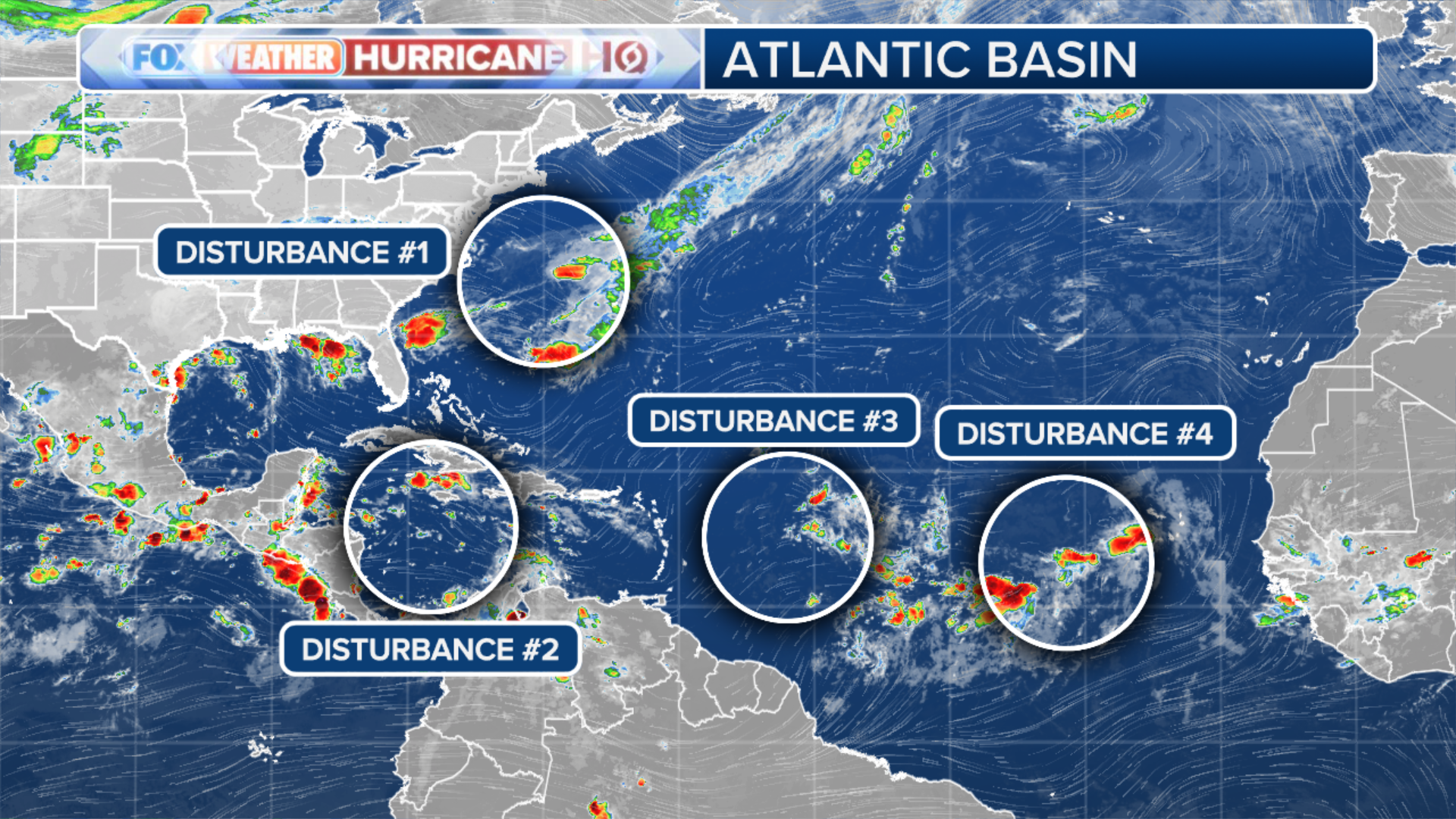
MIAMI – It’s been one of the quietest stretches of tropical activity in more than 50 years in the Atlantic, but hurricane forecasters continue to monitor four tropical disturbances that could develop over the next week.The National Hurricane Center (NHC) is monitoring three areas of disturbed weather in the Atlantic Ocean while a third area spins across the Caribbean on a path that could eventually bring it into the warmer waters of the Bay of Campeche and Gulf of Mexico.HOW TO WATCH FOX WEATHERDr. Phil Klotzbach, a hurricane specialist at Colorado State University, said he expects tropical cyclone activity in the Atlantic Basin to remain at normal or below-normal levels through at least mid-September.In fact, the lack of tropical activity between Aug. 12 through Sept. 3 marked the quietest period in tropical weather development in 56 years. But with the statistical peak of the 2024 Atlantic hurricane season upon us, now is a good time to look over important hurricane supplies and make sure you and your family have a plan of action in case activity continues to pick up in the coming weeks.DOWNLOAD THE FREE FOX WEATHER APPThe first tropical disturbance is swirling over the Caribbean as it quickly moves off to the west. It is currently producing a large area of showers and thunderstorms near southeastern Cuba, Jamaica and across parts of the central Caribbean.The NHC said the system could develop later this week when the disturbance slows down over the northwestern Caribbean or early next week over the southwestern Gulf of Mexico.The NHC is giving the system a low chance of developing over the next week.SUMMER WEATHER RECAP: WHO BAKED IN THE HEAT AND WHO ESCAPED THE FRYING PAN?Another tropical disturbance located about 800 miles east of the Lesser Antilles is continuing to produce an area of disorganized precipitation and thunderstorms.The NHC said that the development of this system, if any, will likely be slow over the next few days.The tropical disturbance is forecast to move off to the west-northwest over the next few days, and environmental conditions are expected to become unfavorable for further development by the end of the week.The NHC is giving the system a low chance of developing over the next seven days.SEPTEMBER TO MAKE OR BREAK ROBUST HURRICANE SEASON OUTLOOKSThe third tropical disturbance is located over the far eastern Atlantic Ocean and is also producing an area of disorganized showers and thunderstorms.The NHC said some slow development of this system is possible over the next few days as it slowly moves off to the northwest. The system could also produce some locally heavy rain in portions of the Cabo Verde Islands on Wednesday.The NHC is giving the system a low chance of developing over the next week.Yet another area has popped up in the northwestern Atlantic worth watching, according to the NHC. A non-tropical area of low pressure located a few hundred miles east of North Carolina is producing disorganized showers and thunderstorms.The NHC said this system could acquire some subtropical characteristics over the next few days as it moves north-northeastward, remaining offshore of the northeastern U.S.It has a low chance of development over the next seven days.