


The Dam Rock Station Playing Anything that Rocks!!
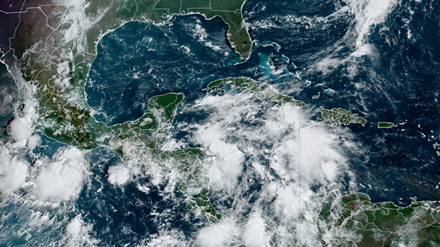
Millions of people living along the Gulf Coast are being urged to make sure preparations are in place as the next tropical threat to the U.S. brews in the Caribbean, and there are increasing signs that the ingredients needed for a tropical storm or hurricane to form are coming together.A number of computer forecast models depict a strong tropical storm or hurricane in the eastern Gulf of Mexico by the end of this week, but there still remains a lot of uncertainty in the forecast, with several potential outcomes.The system expected to threaten the Gulf Coast has now been dubbed Invest 97L, which is simply a naming convention that allows the National Hurricane Center (NHC) to run specialized computer models to help forecasters obtain additional information on tropical disturbances being monitored for development. WHAT IS AN INVEST DURING HURRICANE SEASON?The development odds for Invest 97L have been steadily increasing, and the NHC says there is a high chance of tropical development from the northwestern Caribbean Sea to the southern and eastern Gulf of Mexico over the next seven days.The NHC says a broad area of low pressure is currently producing disorganized showers and thunderstorms over the northwestern Caribbean Sea and portions of Central America.”Environmental conditions appear conducive for development of this disturbance, and a tropical depression or tropical storm is likely to form during the next few days while the system moves northward across the northwestern Caribbean Sea and into the southeastern Gulf of Mexico,” the NHC said in its latest tropical weather outlook. HOW TO WATCH FOX WEATHERThe system is expected to dump heavy rain over portions of Central America during the next several days, according to the NHC.The NHC said areas of the northwestern Caribbean, Mexico’s Yucatán Peninsula and western Cuba should closely monitor the progress of the system.Later this week, the NHC says the system is expected to move northward over the Gulf of Mexico, and communities along the northern and northeastern Gulf Coast should also stay alert.”How strong the storm will be and exactly where the most intense effects will occur is an open question,” FOX Weather Hurricane Specialist Bryan Norcross wrote. “There is a general consensus in the various computer forecasts on how the steering pattern will evolve, but it’s the details that make a difference in whether a storm hits one location or another location hundreds of miles away.”Through Monday, the development chances for Invest 97L will likely continue to increase, and a tropical depression or tropical storm could form in the western Caribbean by Tuesday.BRYAN NORCROSS: LATE-WEEK IMPACTS ON NORTHERN US GULF COAST BECOMING MORE LIKELYNorcross said Hurricane Watches could then be issued for portions of the U.S. Gulf Coast, and we could be tracking Tropical Storm Helene by the middle of the week.On Thursday or Thursday night, the storm, whether it’s a tropical storm or Hurricane Helene, could make landfall somewhere between Louisiana and Florida.DOWNLOAD THE FREE FOX WEATHER APP”Residents on or near the coast between Louisiana and Florida should stay well informed,” Norcross continued. “This will be a fast-developing situation, so now is the time to think through what you would do in the potentially affected areas if a significant storm comes your way late in the week.”By Friday, the storm will likely begin to weaken as it moves inland across the Southeast. However, it will continue to produce heavy rain and gusty winds along its path.Pieces of this complicated weather puzzle are slowly coming together. That includes a weather pattern known as the Central American Gyre. The gyre is a sprawling area of low pressure that feeds off moisture streaming in from the Pacific Ocean and forms near or over Central America. At its core, it is a heavy rain producer with impacts extending outwards hundreds of miles and leading to threats of torrential rainfall, flooding and landslides for more than a dozen countries centered in and around Central America.WHAT IS THE CENTRAL AMERICAN GYRE?However, organized low-pressure centers can develop into tropical storms or even hurricanes within the larger gyre if water temperatures and upper-level winds become favorable for tropical development. Current water temperatures in the Caribbean are near the record-warm levels set last season. The ultimate fate of tropical development will depend on the location of the gyre, how strong it becomes and the atmospheric steering – or blocking – patterns occurring in the southern U.S.