


The Dam Rock Station Playing Anything that Rocks!!
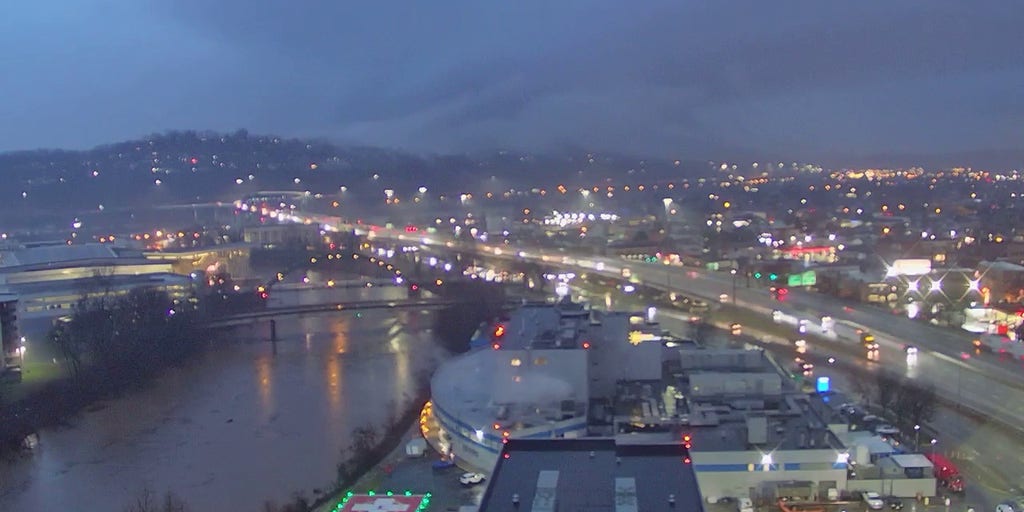
HUNTINGTON, W. Va. – A life-threatening situation unfolded across portions of West Virginia on Thursday morning as powerful thunderstorms moved across the region, leading to numerous reports of flooding, high-water rescues and rockslides due to torrential rain.The National Weather Service office in Charleston, West Virginia, issued a dire Flash Flood Emergency for the Huntington area due to the rapidly developing situation.HOW TO WATCH FOX WEATHERSeveral inches of rain fell in a short period of time in many locations. Forecasters said at least 3.3 inches of rain fell in Huntington overnight into Thursday morning.According to Cabell County 911, residents of Enslow Park, a community within Huntington, had been urged to shelter in place or, if possible, seek higher ground or move to the highest levels of their homes.”Enslow Park is experiencing high water, please evacuate if possible,” officials said. “If you are unable to, contact 911 immediately.”Huntington resident Christine Hankins spoke with FOX Weather via phone on Thursday morning and said heavy rain began to move into the area late Wednesday night, and no one was expecting the situation to become as dangerous as it was on Thursday morning.NATIONAL WEATHER SERVICE REVAMPS FLOOD ALERTS”I actually got home last night, it was about 10:45, and it was starting to rain pretty substantial,” she said. “It just continued through the overnight hours with several different storms coming through our area.”And with the rain pelting down throughout the overnight hours, Hankins said she woke up because an emergency alert was blaring.”When I got up this morning at 6, I was actually woken up by my emergency system going off, alerting us to the Flood Warning for our area.”It’s not uncommon, Hankins said, but this seemed different.”We’ve had that happen in our area before, but this was definitely more substantial,” she said. “And so I got up this morning and I knew it was going to be difficult for me to travel for work just from the location where I was at.”Hankins said she, her family and her friend are all safe, but her mother and sister, as well as some coworkers, did experience flooding at their homes.”Most of us have experienced this before to some degree, so, thankfully, we have the correct things in place to be able to prepare when water does start coming in,” she said.Hankins said that water had, thankfully, started to recede, but trying to get around town was still tough.Several school districts announced they would be closed on Thursday because of the dangerous situation. Many roads in the area were impassable due to high water or debris in the roadway, such as trees and rocks.Roads that were affected include Interstate 77 and Interstate 64, as well as countless local roads and highways such as WV-10, WV-34, WV-61 and US-119.While flooding was a major concern, severe weather, including tornadoes, was also an issue on Thursday.7 WARNING SIGNS A LANDSLIDE OR MUDSLIDE IS IMMINENTVideos from the Charleston area showed dark storm clouds that rolled across the region and produced vivid flashes of lightning that lit up the sky.To the west in Kentucky, sirens wailed during a Tornado Warning in Hart County near the community of Bonnieville earlier in the morning on Thursday.National Weather Service storm survey teams from Louisville, Kentucky, confirmed at least EF-1 damage in northeastern Hart County.HOW PUBLIC SAFETY OFFICIALS NOTIFY YOU DURING SEVERE WEATHER EMERGENCIESA large portion of Kentucky had been included in a Tornado Watch, but as the storms moved off to the east, the watch was allowed to expire at 11 a.m. ETHOW LONG DO TORNADOES LAST AND HOW DO THEY FORM?Several Tornado Warnings were issued Thursday morning in portions of Kentucky, as well as western West Virginia.