


The Dam Rock Station Playing Anything that Rocks!!
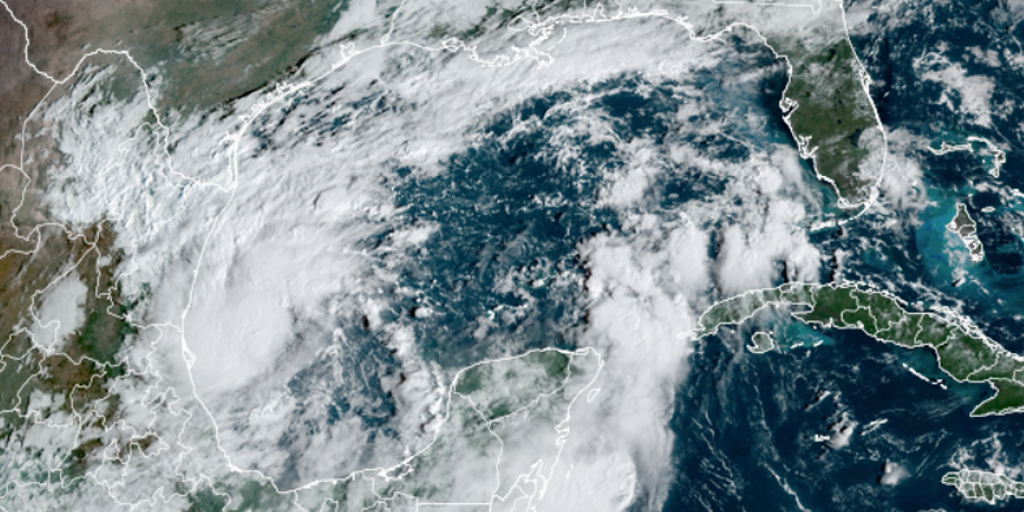
MIAMI — An alarming change in the forecast now shows the potential for a dangerous hurricane to strike the west coast of Florida during the workweek with damaging winds, life-threatening storm surge and torrential rain.The budding cyclone was designated Tropical Storm Milton on Saturday afternoon by the National Hurricane Center, but it’s now expected to rapidly intensify into a hurricane by Monday and reach Florida on Wednesday.TRACKING MILTON: SPAGHETTI MODELS, FORECAST CONE, LIVE RADAR AND MOREThe forecast with Milton has evolved quite a bit in the last 24 hours, showing greater potential to be a more significant storm.”I don’t like the way this is developing at all, and it’s going to happen pretty quickly,” says FOX Weather Hurricane Specialist Bryan Norcross. “It just means the odds are significantly higher (Saturday) than they were (Friday) that a memorable, impactful storm is going to impact Florida in the days ahead.”Milton is forecast to pick up speed early next week and turn to the east/northeast across the central and eastern Gulf of Mexico, reaching hurricane strength on Monday with rapid strengthening likely during the early part of the week, according to the NHC. On the current schedule, Milton would arrive at the Florida Peninsula around Wednesday, although winds could increase late on Tuesday. Well in advance of the storm, waves of heavy rain are forecast beginning Sunday, especially in Central and South Florida.”The GFS (model) and the European (model) have a significant storm offshore (of Florida on Wednesday),” Norcross said. “How significant is this? Yes, it could be a hurricane. Decent chance. And these models, they say hurricane. Could it be a strong hurricane? Category two, Category three. We can’t even rule that out.”The National Hurricane Center is now forecasting Hurricane Milton to make landfall around the Tampa metro as a Category 3 hurricane.”There is really no good news in any of these various computer forecasts, but here we are,” said Norcross. The NHC echoes those concerns.”Regardless of the exact details of the intensity forecast, an intense hurricane with multiple life-threatening hazards is likely to affect the west coast of the Florida Peninsula next week,” the agency said Saturday morning. Norcross says it’s too early to predict how much storm surge this system could generate on Florida’s West Coast, as it’ll depend on Milton’s track and where it makes landfall in western Florida. But it will be significant and dangerous. “In some areas, it will likely be higher than in Hurricane Helene,” Norcross said. “It’s critical that everybody in Central and South Florida stay well-informed since things are developing quickly.”Ahead of the storm, Governor Ron DeSantis issued a state of emergency for dozens of counties from South Florida to northern parts of the state.Forecast models show the heaviest rainfall is expected to be from the Interstate 4 corridor and southward, where a widespread area could see 4-6 inches of rainfall over the next week, with some areas nearing a foot of rain.Because much of the rain will be spread out over several days, widespread flooding is not anticipated, but where thunderstorms repeatedly move over the same region, issues could arise.The expected impacted region is farther south from where Hurricane Helene made landfall last week, so the hardest-hit areas of the Big Bend will not receive as much rainfall as locations such as Fort Myers, Orlando, Tampa and Miami.In addition to the rainfall, rough seas will lead to threats of increased rip currents and erosion along beaches – a pattern that will continue well into next week.FLORIDA ALLIGATOR FINDS BREAK IN RAINY WEATHER TO SUNBATHE ON A BEACH”The bottom line is we do have the potential for a significant, problematic, impactful storm coming toward Florida Tuesday, Wednesday-ish of next week,” Norcross said.The waters in the Caribbean Sea and the Gulf remain plenty warm for development, and October is typically the month with the most landfalls in South Florida.According to NOAA historical data, more than 60% of landfalls in the region occur after the climatological peak of the hurricane season, which is Sept. 10.The latest date a hurricane has ever hit the Sunshine State is Nov. 21, when Hurricane Kate slammed into the Florida Panhandle in 1985.The National Hurricane Center continues to monitor Hurricane Kirk in the central Atlantic and Hurricane Leslie in the eastern Atlantic, which are expected to have greater impacts on Europe than the U.S.There is also a new disturbance off the coast of Africa that is being tracked but only slow development is expected.