


The Dam Rock Station Playing Anything that Rocks!!
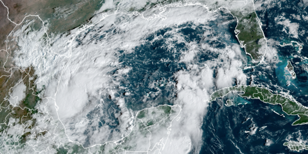
As of Sunday at 2:00 P.M. ET, Tropical Storm Milton strengthened into Hurricane Milton. Continuous coverage of Hurricane Milton as it barrels toward Florida has moved here.TAMPA – Florida is preparing for what will likely be the largest evacuation the state has seen since 2017 as forecasters continue to monitor Tropical Storm Milton, which is expected to become a major hurricane and bring a life-threatening storm surge, damaging winds and flooding rain to the state this week.Florida Gov. Ron DeSantis and other state officials held a news conference on Sunday morning and said evacuations are likely, and time is running out to prepare for the eventual hurricane’s potentially deadly impacts.TRACKING MILTON: SPAGHETTI MODELS, FORECAST CONE, LIVE RADAR AND MORE”I urge Floridians to finalize your storm preparations now; enact your plan,” Florida Division of Emergency Management Director Kevin Guthrie said. “I highly encourage you to evacuate. We are preparing, and I have the State Emergency Response Team preparing, for the largest evacuation that we have seen most likely since 2017 Hurricane Irma.”If eventual Hurricane Milton makes landfall in Florida, it will be the third to do so this season following the landfalls of Debby in August and Helene in September.The situation has been quickly unfolding since Saturday when the National Hurricane Center (NHC) first designated the evolving tropical cyclone as Tropical Depression Fourteen early in the morning and then as Tropical Storm Milton just hours later.The storm is expected to rapidly intensify into a hurricane on Sunday, and then into a major hurricane (Category 3 or higher) by Monday evening.The current forecast calls for Milton to at least reach Category 3 strength, but some computer forecast models show Milton flirting with Category 4 strength, which starts when maximum sustained winds reach at least 130 mph.Milton is forecast to pick up speed early this week and turn to the east-northeast across the central and eastern Gulf of Mexico, reaching hurricane strength on Monday with rapid strengthening likely during the early part of the week, according to the NHC. On the current schedule, Milton would reach the Florida Peninsula around Wednesday, although winds could begin to increase as soon as late Tuesday. Well in advance of the storm, waves of heavy precipitation are expected over the next few days, especially in Central and South Florida.The NHC is now forecasting Hurricane Milton to make landfall near or south of the Tampa metro as a Category 3 hurricane.”There is really no good news in any of these various computer forecasts, but here we are,” FOX Weather Hurricane Specialist Bryan Norcross said.The NHC echoes those concerns.”Regardless of the exact details of the intensity forecast, an intense hurricane with multiple life-threatening hazards is likely to affect the west coast of the Florida Peninsula next week,” the agency said. Norcross says it’s too early to predict how much storm surge this system could generate on Florida’s west coast, as it’ll depend on Milton’s track and where it makes landfall in western Florida. But it will be significant and dangerous. “In some areas, it will likely be higher than in Hurricane Helene,” Norcross said. “It’s critical that everybody in Central and South Florida stay well-informed since things are developing quickly.”Ahead of the storm, Gov. Ron DeSantis issued a state of emergency for dozens of counties from South Florida to northern parts of the state.Forecast models show the heaviest rainfall is expected to be from the Interstate 4 corridor and southward, where a widespread area could see 5-8 inches of rainfall over the next several days, with some areas nearing a foot of rain.Because much of the rain will be spread out over multiple days, widespread flooding is not anticipated, but issues could arise where thunderstorms repeatedly move over the same region.The expected impacted region is farther south from where Hurricane Helene made landfall last week, so the hardest-hit areas of the Big Bend will not receive as much rainfall as locations such as Fort Myers, Orlando, Tampa and Miami.In addition to the rainfall, rough seas will lead to threats of increased rip currents and erosion along beaches – a pattern that will continue throughout the week.On its current path, Hurricane Milton will not travel up through the Southeast like Hurricane Helene, but rain from Milton’s outer bands could reach South Carolina and Georgia and is expected to stay well south of North Carolina and Tennessee.FLORIDA ALLIGATOR FINDS BREAK IN RAINY WEATHER TO SUNBATHE ON A BEACHThe waters in the Caribbean Sea and the Gulf remain plenty warm for development, and October is typically the month with the most landfalls in South Florida.According to NOAA historical data, more than 60% of landfalls in the region occur after the climatological peak of the hurricane season, which is Sept. 10.The latest date a hurricane has ever hit the Sunshine State is Nov. 21, when Hurricane Kate slammed into the Florida Panhandle in 1985.The National Hurricane Center continues to monitor Hurricane Kirk in the central subtropical Atlantic and Hurricane Leslie in the central tropical Atlantic, which are expected to have greater impacts on Europe than the U.S.There is also a new disturbance off the coast of Africa that is being tracked, but only slow development is expected.