


The Dam Rock Station Playing Anything that Rocks!!
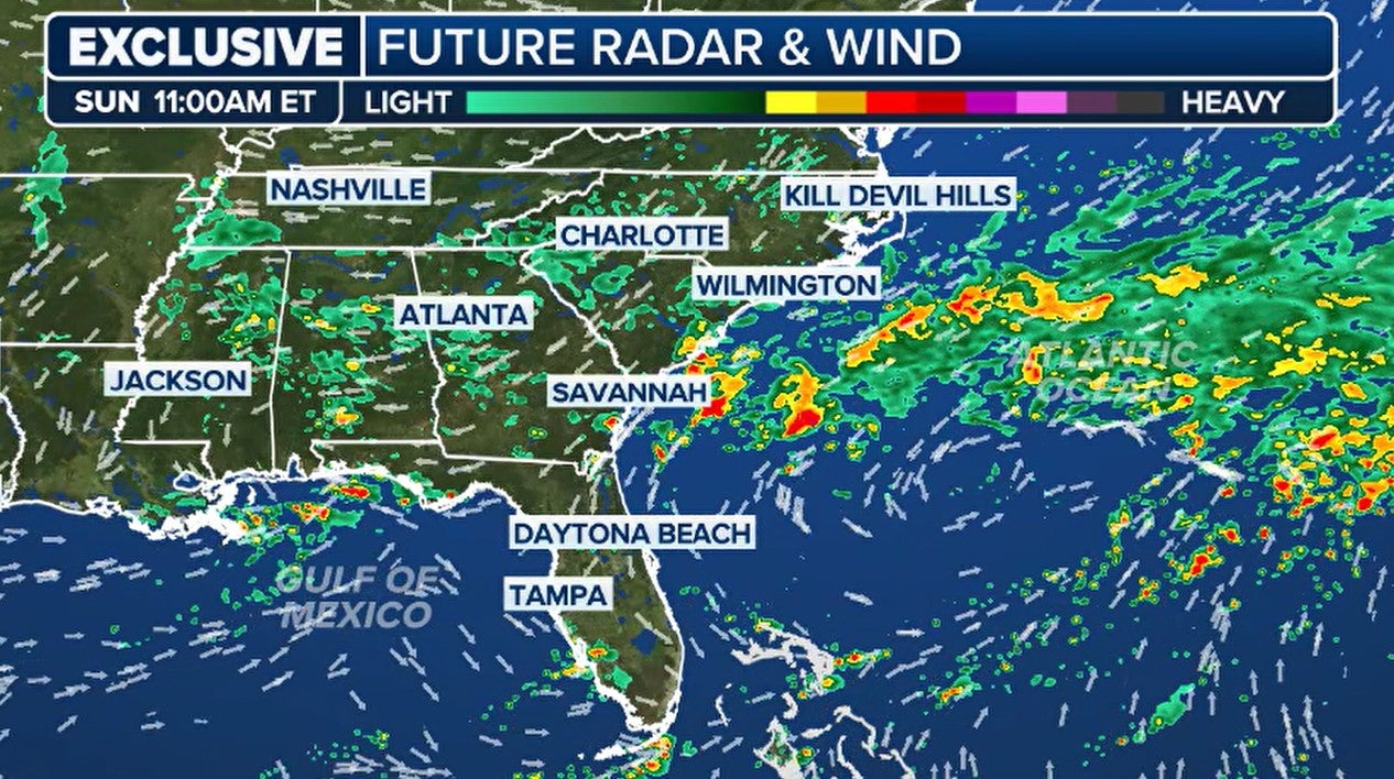
RALEIGH – On the heels of Hurricane Francine, which is raining itself out over the Tennessee Valley, the Fox Forecast Center is monitoring an old frontal boundary off the coast of the Southeast, which could be the focal point for the season’s next tropical disturbance. The National Hurricane Center has given the area a low chance of development over the next week, but cyclone or not, the Carolinas are in store for rainy and, at times, blustery conditions over the weekend and into the first half of the workweek.Environmental conditions are not too conducive to rapid development, but some slow organization is possible as the disturbance works north and westward, back toward the coastline.Due to the persistent onshore flow, impacts on the mid-Atlantic and Carolinas will not deviate if the system organizes into a cyclone or not.Forecast models show a widespread swath of 2-5 inches of rainfall, with locally heavier amounts expected to fall mainly east of Interstate 95. This includes the coastal communities of Myrtle Beach in South Carolina and Wilmington and Morehead City in North Carolina. More modest rainfall amounts are expected in inland communities such as Raleigh, Charlotte and even in Richmond, Virginia.WATCH: HURRICANE ERNESTO’S SWELL CAUSES NORTH CAROLINA HOUSE TO COLLAPSE INTO OCEANAll of the motion in the ocean will lead to rough surf, an increased threat for rip currents and the potential for additional coastal erosion. The coastline around the Outer Banks and southeast Virginia is highly susceptible to rough seas, as evidenced by swells created by Hurricane Ernesto that were over 1,000 miles away. Waves triggered by the once-Category 2 hurricane caused flooding along North Carolina Highway 12, the main thoroughfare through the islands, and at least one abandoned home collapsed into the ocean.Following the collapse, parts of the Cape Hatteras National Seashore were off-limits to swimmers due to concerns about debris in the water.So far, authorities have given no indications that the surf will outdo the swells of Ernesto or claim any more homes, but the local National Weather Service office in Morehead City, North Carolina, has issued various advisories for beachgoers and boaters, warning about the rough conditions.WHEN IS THE TYPICAL LAST HURRICANE STRIKE ON THE US COAST?Elsewhere in the Atlantic basin, the NHC is monitoring two features, but neither pose significant threats to land. The first area is a complex of showers and thunderstorms known as Invest 94L. An invest is simply the naming convention used by forecasters to identify an area they are investigating for possible tropical development.Invest 94L is approaching the northern Leeward Islands and will enhance shower activity, but the combination of shear and dry air is expected to limit the system’s organization.A second area the NHC is monitoring is nearly halfway between the Caribbean Sea and Africa and is known as Tropical Depression 7. Throughout the system’s lifespan, the tropical depression is expected to remain out in the open Atlantic and not threaten any landmasses. The next system that earns the tropical storm designation will be named ‘Gordon.’Typically, the seventh-named system in the Atlantic basin forms around September 3, meaning 2024 is running behind an average season for the number of total named storms.