


The Dam Rock Station Playing Anything that Rocks!!
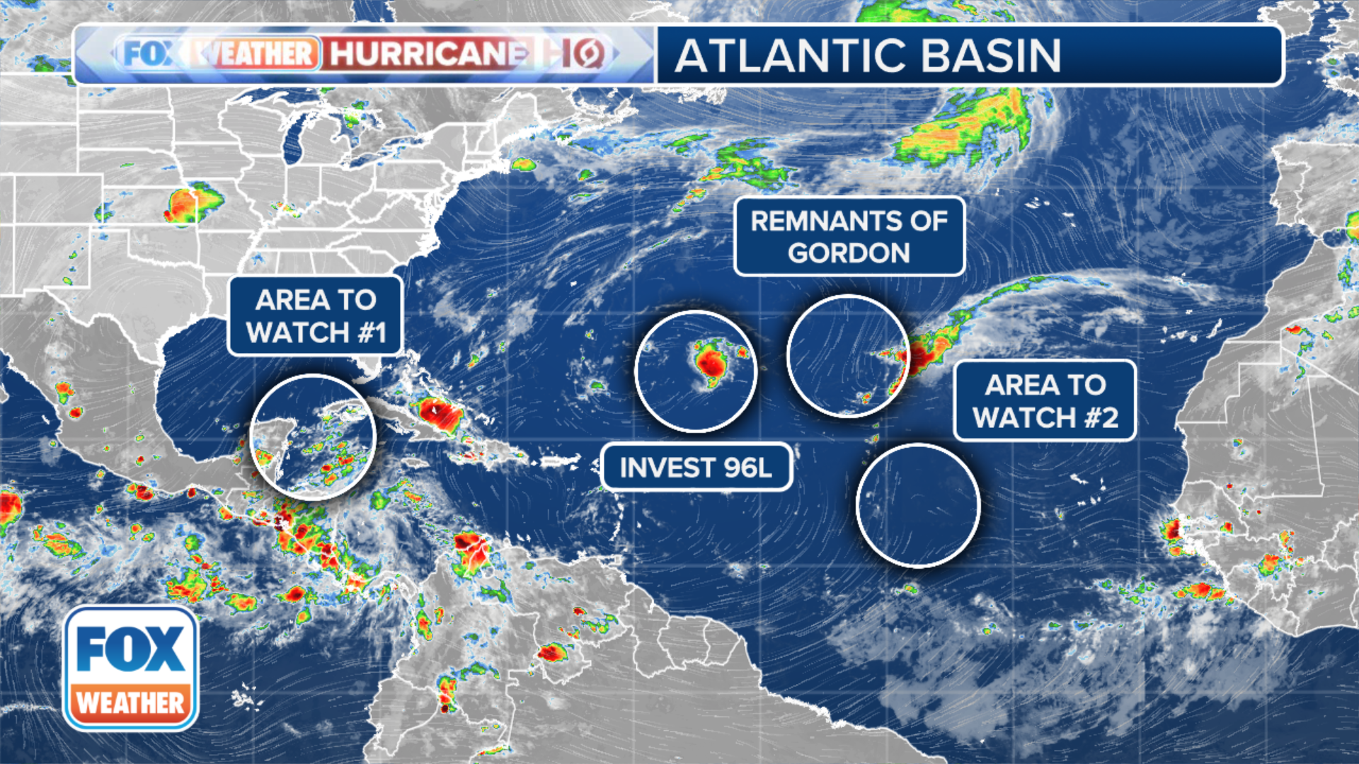
As concern grows in the Gulf of Mexico and Caribbean for a potentially future tropical system next week, a new area of possible tropical development is under the watchful eyes of the National Hurricane Center in the eastern Atlantic Ocean. Meanwhile, two other areas under tropical consideration – the remnants of what was Tropical Storm Gordon days ago and a nearby disturbance tagged as Invest 96L – appear to be on their final gasp.The new area under watch is expected to catch a tropical wave coming off the African west coast within the next few days, according to the NHC. Conditions are favorable for gradual tropical development next week as it moves west-northwest over the eastern Atlantic. Right now, the agency is just giving medium odds of tropical development over the next week, but further development may loom beyond seven days.What used to be Tropical Storm Gordon earlier this week fizzled into a disorganized band of showers and thunderstorms. But then the system showed some potential signs of a return to life, and the NHC gave as much as a 60% chance of the storm regenerating into Tropical Storm Gordon status.However, the associated shower and thunderstorm activity never became better organized, and now it appears the former Gordon’s attempt to return to prominence is going to falter. The NHC has dropped the (re)development odds to just 10% on Saturday. Regardless of its designation, the system will continue to stay well out to sea and remain the only storm this hurricane season not to make landfall, according to the FOX Forecast Center.Another tropical disturbance that lurked just to the west of Gordon’s remnants some 700 miles northeast of the northern Leeward Islands caught enough of the NHC’s attention to become labeled Invest 96L – meaning the agency could start running special computer models on the budding storm to monitor for future development.WHAT IS AN ‘INVEST’?Those models are now unimpressed. The NHC says environmental conditions no longer appear conducive for significant development of this system during the next couple of days, and has dropped the odds of forming a tropical depression to just 10%. The disturbance was no threat to land anyway. The best chance of tropical development over the next week remains the Caribbean and Gulf of Mexico. Atmospheric conditions are still becoming increasingly favorable for the formation of a named storm sometime next week.The growing concern is linked to the Central American Gyre, a weather pattern known to contribute to tropical storm development in the region during early spring and autumn. While the current odds of development are medium, the situation warrants close monitoring, according to the FOX Forecast Center. BUDDING TROPICAL THREAT IN THE CARIBBEAN, GULF OF MEXICO SORTS INTO THESE 4 SCENARIOS