


The Dam Rock Station Playing Anything that Rocks!!
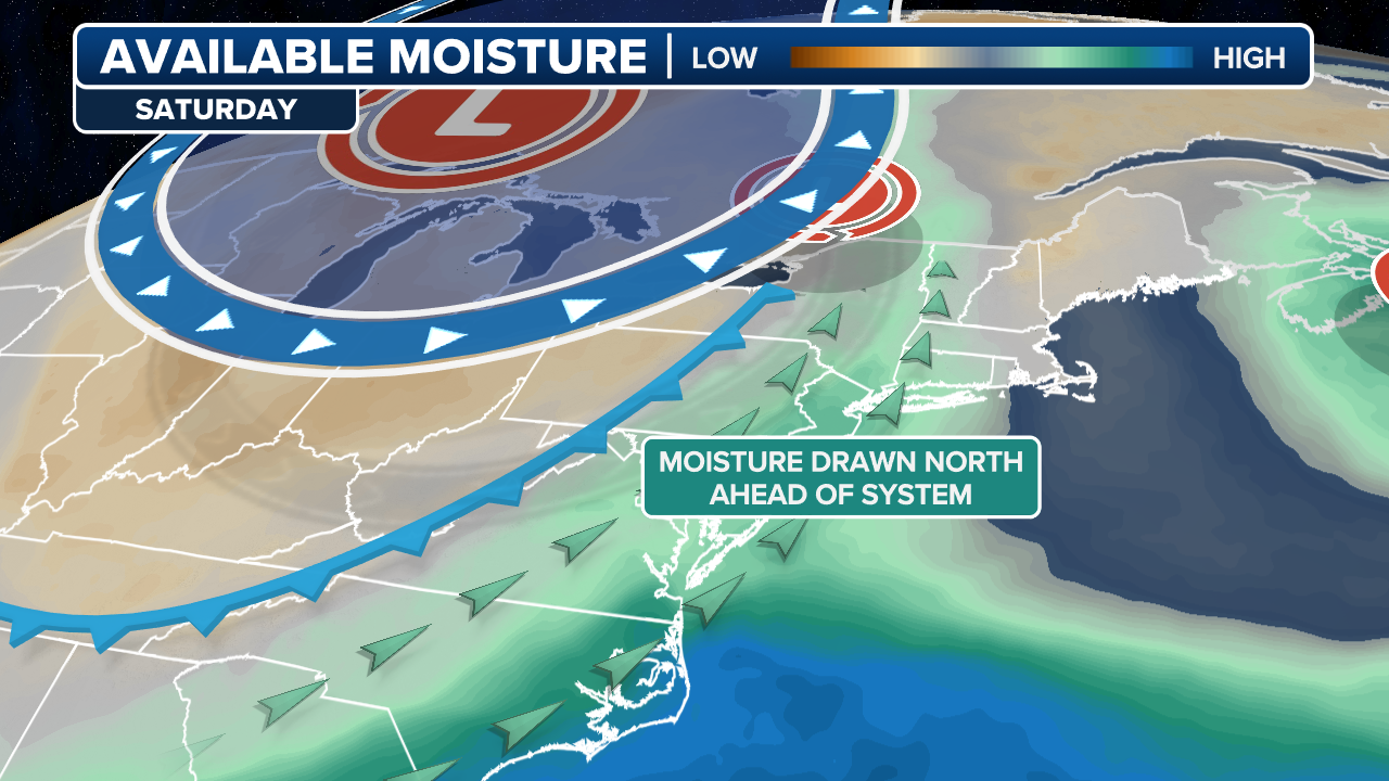
What has been a roller-coaster start to meteorological fall in the Northeast will continue to be topsy-turvy as not one, but two storm systems are forecast to venture close to the region over the upcoming weekend.The combination of a frontal boundary from Canada and a non-tropical area of low pressure off the Eastern Seaboard are set to make for a few blustery days that could even be accompanied by a few passing showers.The precipitation will be courtesy of a frontal boundary that will push in from the west, setting the stage for at most an inch or two of precipitation, especially for Upstate New York.”This really starts to feel like fall for me when you start to get the…fronts coming through,” said FOX Weather meteorologist Ari Sarsalari. “The idea that it cools off, then it warms up in advance of the next front. Then the front comes through. It’s a very noticeable cooldown, and you kind of rinse and repeat. It’s the time of year when you get a lot of ups and downs.”HERE’S WHEN TO EXPECT THE FIRST FREEZE OF THE SEASONCloser to the coast and along the Interstate 95 corridor, the FOX Weather Center will be watching another frontal boundary and an area of low-pressure offshore, which will help kick up the surf and potentially keep the beaches rather blustery.The National Hurricane Center is monitoring the area of low pressure for subtropical development; however, chances are low it organizes into a named feature and even lower that it ventures near the coastline.If any rainfall does occur in the big cities, it is likely to originate along the fall frontal boundary from Canada versus the subtropical feature, as the jet stream has the features generally marching from west to east across the region.New York communities such as Syracuse and Buffalo begin to see rain chances increase late Friday night and last into early Sunday, while cities such as Hartford, Connecticut and Boston see their best chance of rain on Saturday, but coverage is only around 30%.WHAT DOES A SIZZLING SUMMER MEAN FOR AUTUMN LEAVESTemperatures that are above normal levels to start will stand to plummet with the added rainfall and increased cloud cover.A city such as Buffalo, which is expected to be in the 80s during the remaining days of the workweek, is forecast to only see highs in the 60s starting over the weekend and lasting into next week.Places along the coast will have less of a steep dive with 80s turning into 70s, so for a city such as New York, it’ll mean being just a few degrees below average.”We head into maybe a pattern that’s going to lend to slightly cooler than average temperatures,” said FOX Weather meteorologist Stephen Morgan. “So that’s what I think the focus, at least for me, the rains one thing but these cool temps.”During the first month of September, highs in the Northeast typically range from the mid-70s inland to near 80 degrees along the coast.According to the latest forecast models, once the storm systems push past the region on Monday, there doesn’t appear to be a significant warming trend that will raise temperatures above average until the middle of the week.”It’s that kind of change that does, whether we like it or not, mentally signals a change of seasons and a change of feel,” said FOX Weather meteorologist Marissa Torres. “I don’t care where you go, everybody’s talking about that hint of fall, that taste of fall.”FARMER’S ALMANAC WINTER OUTLOOK CALLS FOR ‘COPIOUS AMOUNTS OF SNOW, RAIN, SLEET AND ICE’It is possible a few flakes could fly at elevations of above 6,000 feet on Sunday and down to near 5,000 feet on Monday, according to the National Weather Service in Burlington, Vermont.Ingredients such as cold air and moisture must be in place concurrently for the frozen precipitation to happen, but few people will be able to see the event if it occurs.If the snowflakes happen, they would be the first signs of the winter season for places such as Mount Washington, Mount Adams and Mount Jefferson along the White Mountains.The mountain range usually experiences its first measurable snowfall in October, but the timing can vary due to varying weather patterns.