


The Dam Rock Station Playing Anything that Rocks!!
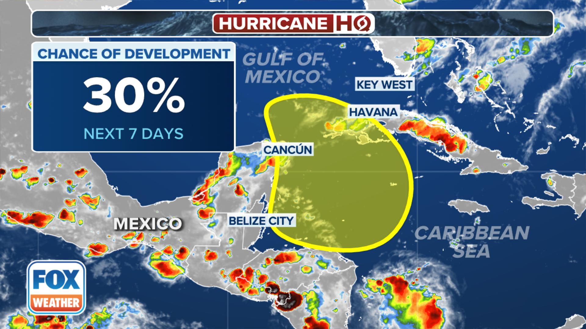
MIAMI – As tropical activity in the Atlantic Ocean quiets down again, attention is shifting back to the Caribbean and Gulf of Mexico, where there are increasing signs of atmospheric conditions favorable for the development of possibly the next named storm sometime next week.The National Hurricane Center is now officially monitoring the area for tropical development. The agency is still giving low odds of development for now within the next seven days but did slightly increase the odds Wednesday evening. Further development may loom beyond seven days, according to the FOX Forecast Center. The growing concern is linked to a phenomenon known as the Central American Gyre, which has historically contributed to tropical storm formation in the Caribbean or Gulf of Mexico in the early spring or autumn.The gyre is a sprawling area of low pressure that feeds off moisture streaming in from the Pacific Ocean and forms near or over Central America. At its core, it is a heavy rain producer with impacts extending outwards hundreds of miles and leading to threats of torrential rainfall, flooding and landslides for more than a dozen countries centered in and around Central America.WHAT IS THE CENTRAL AMERICAN GYRE?Organized low-pressure centers can develop within the large gyre if water temperatures and upper-level winds become favorable for tropical development. And current water temperatures in the Caribbean are near the record-warm levels set last season. Both early and late in the hurricane season are more notorious for seeing a tropical disturbance break away from Central America and form into a tropical entity in either the Eastern Pacific, Bay of Campeche or western Caribbean Sea.”You can get showers and storms, and you can get some of that energy that can fall off of it, spin-off of it, and translate into something that maybe develops out of the Gulf of Mexico, out of the Caribbean,” FOX Weather meteorologist Marissa Torres said.Many computer model forecasts indeed show large amounts of moisture from the Pacific Ocean streaming across Central America and heading into the Caribbean Sea sometime next week to form a potential gyre.Meanwhile, early indications suggest an upper-level dip in the jet stream parked over the central U.S. will move northward, removing a blocking feature that would prevent storms from entering the Gulf of Mexico and also allow the gyre to drift north into the southern Gulf of Mexico.”So if we see that broad circulation and if it does perhaps move into the southern Gulf of Mexico or at the very least pivots a little farther to the north, then that opens a window for possible (tropical) development,” FOX Weather meteorologist Stephen Morgan said. “And assuming we don’t have significant systems moving from land into the Gulf of Mexico – notably fronts that would steer this thing away – there will be an element of the Gulf of Mexico being at play.”While storm formation is never guaranteed, the pattern suggests an active period of rain for the Caribbean, parts of Mexico and likely southern Florida by late next week, according to the FOX Forecast Center. Regardless of if or when any individual storms undergo tropical development, there will be a large plume of tropical moisture in the area by late next week, and it is likely to persist.”(When) you look at the Bay of Campeche, you look at the water temperatures – there are a lot of other elements that are still way conducive for development,” FOX Weather meteorologist Michael Estime said. “We’ll have to watch what happens with the eyre … something that we’re certainly going to watch in the days ahead.”On average, about once every other year, the Central American Gyre produces a tropical cyclone, some of which develop into full-fledged hurricanes if conditions allow.Due to their formation of hotspots in the Caribbean or regions in the southern Gulf of Mexico, many go on to threaten the Southeast coast.Tropical Storm Amanda (2020), Tropical Storm Cristobal (2020), Hurricane Michael (2018), Tropical Storm Andrea (2013) and Hurricane Ida (2009) are all examples of areas of disturbed weather that formed off the Central American Gyre.Hurricane Michael struck the Florida Panhandle as a Category 5 hurricane in 2018 after spending a week embedded in the overall gyre off the coast of Central America.Usually, due to their formation in the early or late season, tropical cyclones directly influenced by the Central American Gyre tend to be weaker when impacting the U.S. due to the prevalence of inhibiting factors such as cooler water temperatures and hostile upper-level winds.