


The Dam Rock Station Playing Anything that Rocks!!
SIOUX FALLS, S.D. (KELO) – While we already saw some storms in western and northern KELOLAND, the bulk of what we’ll be monitoring comes along later this evening and begins out west.
Smithfield Foods under investigation after injury
Showers and thunderstorms will develop West River later in the afternoon/evening and push eastward through sunset and into the night. This is expected to reach the I-29 corridor around or just after midnight before pushing eastward before daybreak on Tuesday. Ahead of all of this, we do at least have the chance to see a few storms develop East River and move through the area later in the afternoon and through the evening commute.
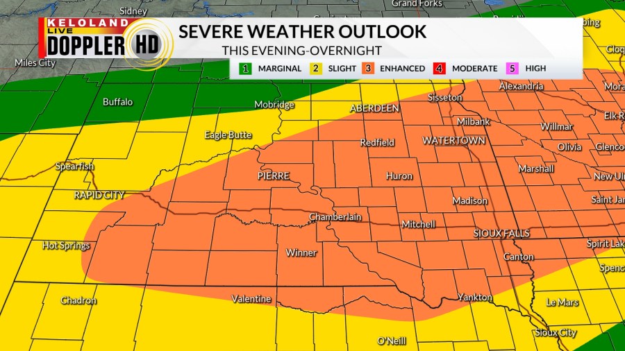
An “Enhanced Risk” for severe weather extends all the way to Wall and Oglala Lakota County and covers a large portion of KELOLAND. “Slight” and “Marginal” risks fill the gaps to the northwest.
A severe thunderstorm watch is in effect for western and southern KELOLAND until 11 pm CDT/10 pm MDT Monday night.
All forms of severe weather are possible…including large hail, damaging winds, and a few tornadoes as well. Be sure to stay weather aware and have your StormTracker App and NOAA Radio ready to go.
Additional showers and thunderstorms are possible on Tuesday as lingering moisture is slow to depart in a few areas. The severe threat on Tuesday, however, is much lower.
The same can’t be said for Wednesday into Thursday. Another round of showers and thunderstorms will move in and impact eastern and central KELOLAND.
A “Slight Risk” is in place for late Wednesday in central and northeastern KELOLAND, with a “Marginal Risk” surrounding that. Wind and hail are the main concerns with any storm that comes along.
After Thursday, we finally get a break from the instability. High pressure builds into KELOLAND and sticks around for a while, giving us seasonable temperatures and a good amount of sunshine. Beyond the 7 day forecast, odds for above average temperatures are favored across the region.
Here’s a look at your extended forecast: