


The Dam Rock Station Playing Anything that Rocks!!
SIOUX FALLS, S.D. (KELO) — The new work and school week has gotten off to a messy start in southeastern KELOLAND with snow continuing to slowly move through that part of the region.
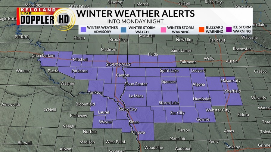
A winter weather advisory will remain in effect through the first half of the night on Monday for southeastern South Dakota, northwestern Iowa, and counties in southwestern Minnesota along the I-90 corridor. Snow totals of 3-5″ are likely with localized higher amounts where banding occurs. Be aware of treacherous road conditions through the evening commute and into the night.
From there, our focus shifts from the snow to bitter cold that blankets KELOLAND for the next several days.
A cold weather advisory is in effect for the US Highway 212 corridor and northwestern South Dakota until 12 pm CST/11 am MST Tuesday as well as portions of KELOLAND along and east of the James River valley. Areas around the US Highway 12 corridor, including Aberdeen, Sisseton, Eureka, and Mobridge, have been upgraded to an extreme cold warning for the same time frame. Wind chills below -40 degrees are possible, especially in the warning area. Please take all necessary precautions and bundle up when you get ready for work and school on Tuesday.
We’ll likely have cold weather headlines through at least Thursday in portions of KELOLAND, so please be sure to plan accordingly as we go through the next several days.
Along with this, we’ll watch low pressure attempt to clip the southeastern portion of KELOLAND on Wednesday into Wednesday evening. We’re not looking at much in the way of accumulation, but snow showers will be possible near and southeast of Sioux Falls.
Thursday is a brief break from the action before snow shower chances return for Friday into Saturday. We’ll try to quiet down again as we head toward President’s Day.
Here’s a look at your extended forecast: