


The Dam Rock Station Playing Anything that Rocks!!
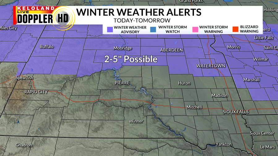
SIOUX FALLS, S.D. (KELO) — The snow is still on track to move into portions of KELOLAND for the start of the weekend. Winter Weather Advisories will be in effect heading into this afternoon for northern South Dakota and will be ongoing until tomorrow morning.
Models have pushed the heavier band of snow northward, which means we will expect the highest snowfall totals to be near the North Dakota border. As the snow expands into northeast South Dakota and Minnesota, these are also areas that have a good chance of picking up over an inch. The rest of KELOLAND will likely stay under one inch, with Sioux Falls having a better shot of reaching that benchmark.
The snow will move in by this evening for western and northern South Dakota. With some of this area seeing light snow already today and more on the way, the evening commute may be impacted.
The snow will begin to become more widespread overnight, with temperatures dropping into the teens and 20s. Blowing snow will be possible as winds begin to increase and turn to the north.
By tomorrow morning, snow will have moved into southeastern KELOLAND and Minnesota. It is a quick moving system that will be out of our area by tomorrow afternoon.
Skies will begin to clear out behind the snow with breezy conditions continuing. Cooler air will arrive behind the low pressure system and drop our highs into the teens and 20s.
Once we dry out by Sunday, the sunshine will return and temperatures will stay around average. Snow chances quickly return for Monday evening as a low pressure system moves off to our south. We will also have an arctic cold front pass, which will drop our highs into the single digits by the middle of the week. By the end of the 7 day forecast, temperatures will warm up, but still stay below average.