


The Dam Rock Station Playing Anything that Rocks!!
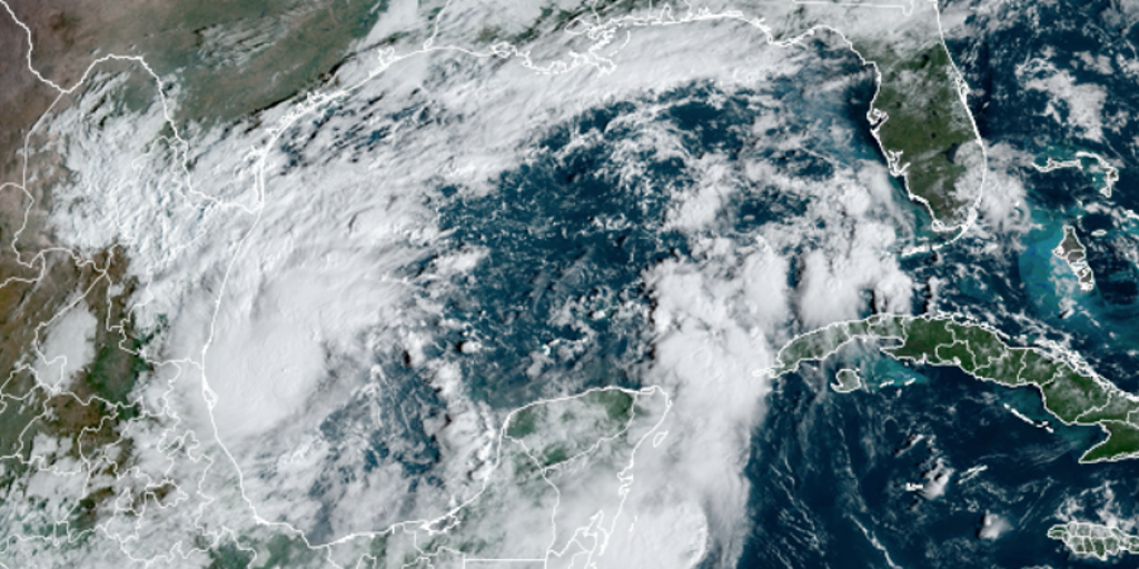
As of Saturday at 11:00 A.M. ET, Tropical Depression Fourteen formed in the Gulf of Mexico and is expected to strengthen into Tropical Storm Milton as it eyes Florida. Continuous coverage of Tropical Depression Fourteen has moved here. MIAMI – The Gulf of Mexico is now on alert for a possible tropical depression or even tropical storm forming this weekend as a disturbance gets better organized. The National Hurricane Center says development of the system, currently designated as Invest 92L, will likely reach at least tropical depression levels by later Saturday or Sunday as it moves slowly east over the southwestern Gulf of Mexico. And then the system may strengthen further in the middle of next week as it moves faster to the east-northeast across the central and eastern Gulf of Mexico, eyeing Florida.”It just means the odds are significantly higher (Saturday) than they were (Friday) that a memorable, impactful storm is going to impact Florida in the days ahead,” says FOX Weather Hurricane Specialist Bryan Norcross.The wet weather is associated with a broad area of low pressure known as the Central American Gyre, which has sent plumes of moisture toward the Sunshine State. Over the next week, a widespread area could pick up 4-6 inches of rainfall, with isolated areas nearing 12 inches, which could cause isolated flooding where precipitation repeatedly moves over the same area.NOAA plans to send Hurricane Hunter aircraft to start investigating the system on Sunday. If the storm reaches tropical storm status, it will take the name Milton. And there are signs the storm could even eventually reach hurricane strength. WHAT IS AN ‘INVEST’?”The GFS (model) and the European (model) have a significant storm offshore (of Florida on Wednesday),” Norcross said. “How significant is this? Yes, it could be a hurricane. Decent chance. And these models, they say hurricane. Could it be a strong hurricane? Category two, Category three. We can’t even rule that out.”He added: “There is really no good news in any of these various computer forecasts, but here we are.””Everywhere on the peninsula of Florida, we’re looking for the potential of significant rainfall starting (Sunday) and then continuing into the week,” Norcross said.DEATH TOLL RISES ABOVE 200 ONE WEEK AFTER HELENE DECIMATES SOUTHEAST COMMUNITIESForecast models show the heaviest rainfall is expected to be from the Interstate 4 corridor and southward, where a widespread area could see 5-8 inches of rainfall over the next week, with some areas nearing a foot of rain.Because much of the rain will be spread out over several days, widespread flooding is not anticipated, but where thunderstorms repeatedly move over the same region, issues could arise.The expected impacted region is farther south from where Hurricane Helene made landfall last week, so the hardest-hit areas of the Big Bend will not receive as much rainfall as locations such as Fort Myers, Orlando, Tampa and Miami.In addition to the rainfall, rough seas will lead to threats of increased rip currents and erosion along beaches – a pattern that will continue well into next week.FLORIDA ALLIGATOR FINDS BREAK IN RAINY WEATHER TO SUNBATHE ON A BEACHIf a tropical cyclone – whether a tropical depression, tropical storm or hurricane – does not form from the current area of disturbed weather, it doesn’t mean that the hurricane season is over for the eastern Gulf of Mexico.The waters in the Caribbean Sea and the Gulf remain plenty warm for development, and October is typically the month with the most landfalls in South Florida.According to NOAA historical data, more than 60% of landfalls in the region occur after the climatological peak of the hurricane season, which is Sept. 10.The latest date a hurricane has ever hit the Sunshine State is Nov. 21, when Hurricane Kate slammed into the Florida Panhandle in 1985.The National Hurricane Center continues to monitor Hurricane Kirk in the central Atlantic and Hurricane Leslie in the eastern Atlantic, but neither poses a direct threat to any landmasses over the next week.There is also a new disturbance off the coast of Africa that is being tracked.