


The Dam Rock Station Playing Anything that Rocks!!
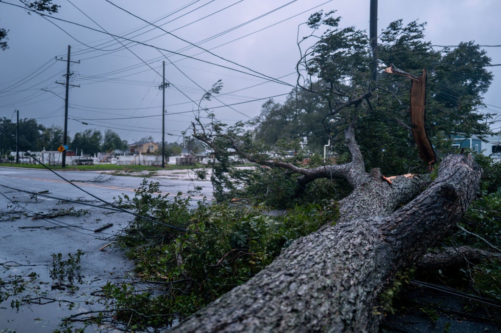
A decaying Francine still has the potential to produce widespread rainfall, gusty winds and even a tornado threat as far north as the Middle Mississippi River Valley as the storm’s moisture envelope slowly pushes northward through the end of the week.Francine made landfall as a Category 2 hurricane on Wednesday afternoon south of Morgan City, Louisiana and started weakening after landfall.The center of circulation is expected to continue well inland, but the storm’s impacts could expand outward hundreds of miles.Francine-related weather alerts, such as wind advisories, Flood Watches and other hazardous weather outlooks, have been posted as far north as southern Missouri and as far east as Tennessee as what is left of the cyclone makes its way through the South.The biggest concern is that heavy rainfall may lead to the weakening of roots and falling trees despite the cyclone being a shell of its former self.”One of the things that really worries me about this setup is sometimes these saturated soils allow trees to come down more easily from the wind when the core of the hurricane moves ashore and that increases the power outages,” said Jamie Rhome, deputy director of the National Hurricane Center.Millions from the Gulf Coast into the middle Mississippi River Valley are under wind advisories, where gusts could reach at least 40 mph during the next 48 hours.HURRICANE FRANCINE CAUSING CANCELATIONS ACROSS GULF COAST AIRLINE, CRUISE TRAVELAs the cyclone’s center generally works northward, a widespread swath of 2-5″ of precipitation will occur through the early weekend.Included in the heavy rainfall zone are communities such as Greenwood, Mississippi; Tuscaloosa, Alabama; Memphis, Tennessee; and Jonesboro, Arkansas.Due to the intrusion of some dry air and how dry the soil already is, a widespread flooding event is not anticipated, but where rain bands train over the same area, localized flooding will be possible, especially in poor drainage areas.The addition of wind shear, increasing dry air and rain bands that will occasionally travel through the Southeast will be the focal point of possible funnel clouds and brief tornadoes through at least Friday.A few parishes were placed under Tornado Warnings on Wednesday before the cyclone made landfall, but so far, no twisters have been reported.Some tropical storms and hurricanes that make landfall along the Gulf Coast are notorious for their production of tornadoes, but, so far, that does not appear to be the case with Francine.Already, two Tornado Watch boxes have been issued for Gulf Coast states, which have included communities such as Biloxi, Mississippi, and Mobile, Alabama, with the threat expected to advance inland over the coming hours.”South-southeasterly surface winds during the late morning will veer to south-southwesterly by the early afternoon hours. This change will reduce low-level shear and lead to some dry-air advection and weaker instability during the afternoon and evening. As a result, the primary tornado threat across the Florida Panhandle and southern Alabama should be confined to the morning hours,” forecasters at the Storm Prediction Center stated. “By early to mid-afternoon, guidance indicates that some clearing of cloud cover may occur across central Alabama. This could lead to surface heating and destabilization, with MLCAPE (Mixed Layer Convective Available Potential Energy) potentially reaching 1000 to 1500 J/kg. This increase in diurnal instability might coincide with the period when the most favorable wind profile exists across the same region. Consequently, there could be a threat of a few tornadic storms in central Alabama during the mid-to-late afternoon.” 7 FACTS YOU SHOULD KNOW ABOUT FLASH FLOODSThe remnants of a hurricane could be welcome news for locales experiencing increasing drought conditions from the Gulf Coast into the southern Ohio Valley.Expected rainfall totals of between 2-5 inches could significantly decrease drought conditions, which range from “abnormally dry” to even “extreme” across the region, according to the latest U.S. Drought Monitor.Drought conditions have even led to low water levels along portions of the mighty Mississippi River, which is an important waterway for barge traffic.According to the U.S. Army Corps of Engineers, water levels still remain in the acceptable range for barge traffic, but weights of products could be limited if low levels persist.A river gauge north of St. Louis recorded a water level of just 3 feet, marking a drop of 6 feet over the past month and more than 10 feet below the usual level for this time of year. Despite the remnants of Beryl and early summer flooding impacting the valley, water levels have generally remained below their average stage.